
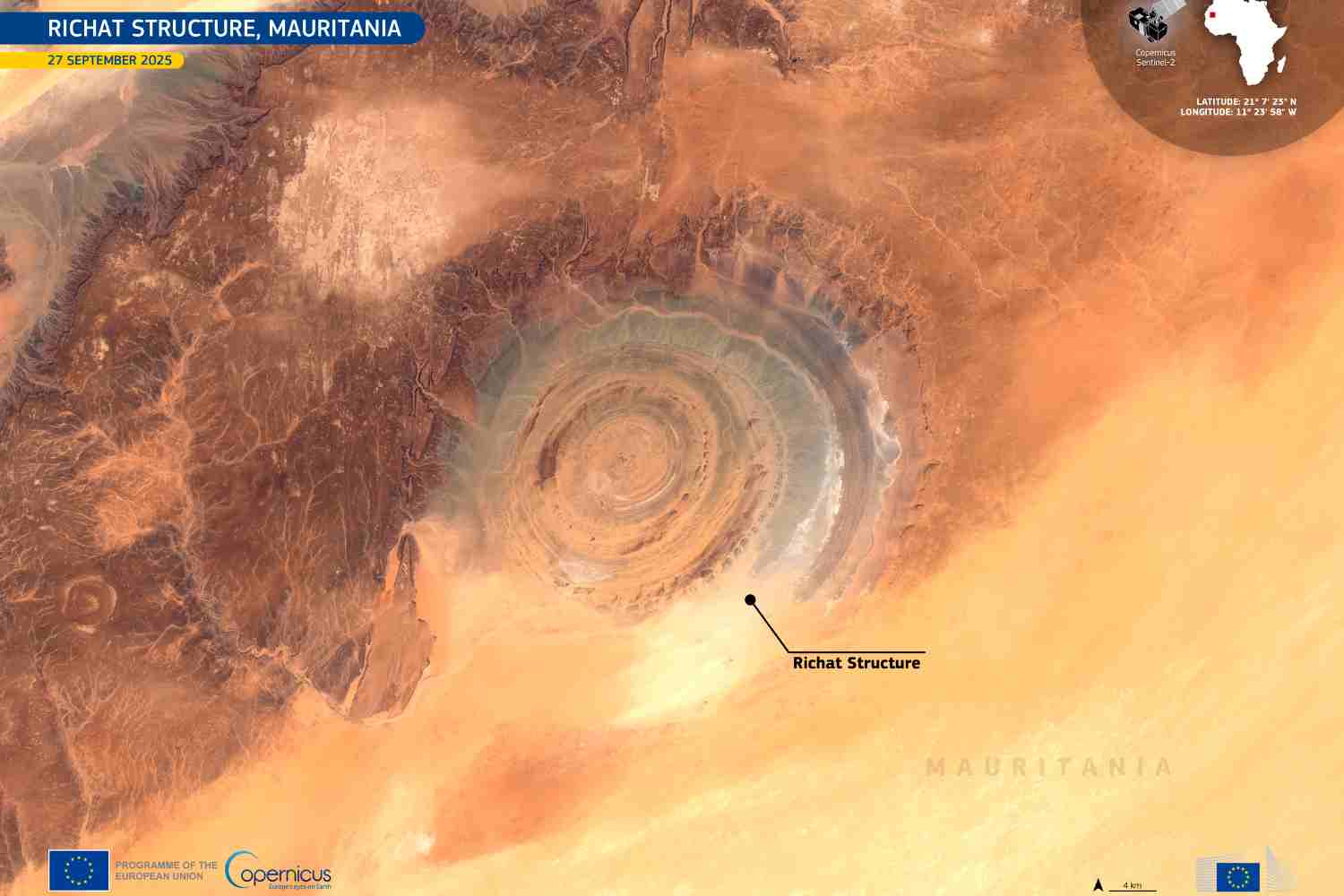
In the Mauritanian Sahara, the Richat Structure—known as the Eye of the Sahara—reveals Earth’s deep history through its vast spiral shape, once mistaken for a meteorite crater.
@European Union, Copernicus Sentinel-2 imagery
In the heart of the Sahara, buried among the endless dunes of Mauritania, lies one of the planet’s most enigmatic geological wonders: the Richat Structure, better known as the Eye of the Sahara or Eye of Africa. From above, it looks like a giant spiral etched into the desert floor—so perfect it almost seems man-made. Yet this formation, spanning roughly 25–30 miles (40–50 km) in diameter, is entirely natural. A new satellite image captured on September 27, 2025 by the Copernicus Sentinel-2 satellite and released by the European Union as the “Image of the Day” has reignited global fascination with this extraordinary landmark.
👁️ The Richat Structure, the "Eye of the Sahara", a striking circular geological formation in 🇲🇷 Mauritania, is among the most distinctive landforms visible from space.
Captured by a #CopernicusEU #Sentinel2 on 27 Sept.
Learn more: https://t.co/X08lxpIhbH#ImageOfTheDay pic.twitter.com/pOXToYQQL0
— Copernicus EU (@CopernicusEU) October 4, 2025
A mystery that puzzled scientists for decades
For years, scientists believed the structure was the result of a meteorite impact. The raised rim and depressed center seemed to point to the violent explosion of an ancient space rock. But geological surveys ultimately shattered that theory. There were no traces of melted rock or a central uplift—both hallmarks of impact craters.
Today, experts agree that the Richat Structure is an eroded geological dome, formed by internal Earth processes during the Cretaceous period, between 145 and 66 million years ago. What makes it spectacular is not only its age, but the way erosion carved its concentric rings into a shape so distinctive it can be seen from orbit.
Rings written in stone
Those rings, perfectly visible from space, are made of alternating layers of sedimentary and igneous rock. Softer materials such as sandstone and shale wore away more quickly, while harder rocks like quartzite and basalt stood firm against wind and time. This natural resistance is what sculpted the circular pattern that still mesmerizes geologists.
At ground level, the relief is subtle: some of the inner rings rise only 260 feet (80 m) above the surrounding terrain. But from a satellite’s eye, the structure’s spiral emerges in astonishing clarity—a fingerprint of deep time etched into the desert.
Traces of ancient lives
The Richat Structure isn’t just a geological curiosity. It also holds signs of human history. Archaeologists have found Acheulean and pre-Acheulean tools—including ancient stone axes—scattered around the site, evidence of prehistoric communities that once passed through this remote region.
Its isolated yet unmistakable shape made it a navigational landmark for pilots during World War II, long before satellites were part of the story. French geographer Jacques Richard-Molard was the first to describe it scientifically, calling it “le boutonnière de Richat” in 1948—a poetic nod to its resemblance to a buttonhole in the fabric of the desert.
A symbol seen from space
The Eye of the Sahara became famous in 1965, when astronauts James McDivitt and Edward White, aboard NASA’s Gemini 4 mission, photographed it from orbit. From that moment on, the structure has stood as a powerful reminder of how space technology can reveal Earth from a radically new perspective.
Today, thanks to continuous monitoring through the Copernicus program, scientists track changes in the Eye of Africa to better understand erosion and geological evolution in remote desert regions. Each new image is a time capsule, documenting how natural forces slowly but relentlessly shape the landscape.
The Atlantis myth that won’t die
Despite clear scientific explanations, the structure’s perfect spiral has fueled countless alternative theories. Some claim it could be the site of Plato’s mythical Atlantis. But geologists are unanimous: there’s no evidence to support this romantic speculation.
The Eye of the Sahara remains what it has always been—a geological masterpiece, not a lost city.
Source: Copernicus.eu