
The European Earth observation program Copernicus, which monitors the atmosphere and oceans through EU satellites, confirms that September 2025 was marked by exceptionally warm seas, retreating polar ice, and anomalous precipitation in many European regions
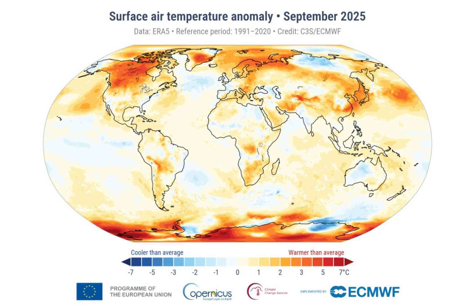
Table of contents
The planet continues to warm, and September 2025 confirms it: according to data from the Copernicus Climate Change Service (C3S), the month just passed was the third warmest September ever recorded globally. Surface air reached an average temperature of 16.11°C (61°F), which is 0.66°C (1.19°F) above the 1991–2020 average and 1.47°C (2.65°F) above preindustrial levels.

@Copernicus
The findings come from the European service managed by the ECMWF (European Centre for Medium-Range Weather Forecasts) as part of the Copernicus program, funded by the European Union. The data is based on the ERA5 reanalysis, which processes billions of measurements from satellites, ships, aircraft, and weather stations around the world.

@Copernicus
“Land and sea temperatures remain persistently elevated, reflecting the continued influence of greenhouse gases in the atmosphere,” said Samantha Burgess, ECMWF’s Deputy Director for Climate.
A planet that won’t cool down
Although slightly lower than the records of 2023 and 2024, September 2025 confirms a troubling trend: the global average temperature over the past twelve months (October 2024 – September 2025) was 1.51°C (2.72°F) above the preindustrial level. This value exceeds the 1.5°C (2.7°F) threshold indicated by the Paris Agreement as the limit not to be crossed to avoid irreversible climate consequences.
Europe sweltering (and underwater)
In Europe, the average September temperature was 15.95°C (60.71°F), or 1.23°C (2.21°F) above normal, ranking fifth among the warmest on record. The greatest anomalies were recorded in Fennoscandia (the northern European region) and Eastern Europe, while some areas of Western Europe experienced slight cooling.
On the precipitation front, the month was marked by intense rainfall and flooding in several European countries, including Italy, Croatia, and eastern Spain, while vast areas of the Iberian Peninsula and the Balkans experienced drier than normal conditions.
Seas getting warmer
The global average sea surface temperature reached 20.72°C (69.3°F), the third highest value ever recorded for September. In the Mediterranean, waters were much warmer than average, particularly in the western and central zones. The marine anomaly is not just a statistical figure: it directly affects climate and the frequency of extreme events, favoring heat waves, hurricanes, and violent precipitation.
Sea ice continues to retreat
Satellite observations show that the Arctic recorded its 14th lowest annual minimum ice extent, with a 12% decline compared to the average. Antarctica also continues to lose ice, with a monthly extent 5% below normal. These figures signal a dual collapse of the poles, increasingly vulnerable to global warming.
What the numbers tell us
The thermal and hydrological anomalies of September confirm that Earth’s climate system is in a phase of persistent overheating, aggravated by record concentrations of greenhouse gases. At the regional level, droughts and floods alternate, clear signs of a balance now compromised.
Behind these data lies a clear signal: the global climate seems to have crossed a critical threshold. Even without the influence of El Niño, temperatures remain very high, a sign that warming caused by greenhouse gases now acts on its own. The oceans, which until now had absorbed part of the excess heat, are returning energy to the atmosphere. It’s as if Earth has stopped “cooling down,” and its climate system is seeking a new equilibrium, warmer and more unstable.
Source: Copernicus